Anyone who’s driven cross-country knows the feeling: you’re staring at a US interstate map, trying to figure out whether I-80 or I-70 gets you there faster, and those red and blue lines start looking like a plate of spaghetti. After years covering the automotive world, I can tell you even seasoned drivers get tripped up by this — not because the system is complicated, but because no one ever explains the logic behind it. In this guide we have broken down how interstate numbering actually works, which routes matter most, and how to read a highway map without losing your way.
Why Bother Learning to Read an Interstate Map?
GPS apps are great, until they’re not. Cell service drops in rural Wyoming. Apps reroute you through a construction zone nobody warned you about. Or maybe you’re planning a trip month out and just want to see the big picture before committing to turn-by-turn directions.
A good us freeway map earns its keep in moments like these. It lets you:
- Compare route options at a glance instead of trusting one algorithm.
- Spot the difference between toll roads and free interstates before you’re stuck paying
- Find rest stops and exits without waiting for the app to tell you
- Plan around construction season, which hits differently depending on the state
- Get a realistic sense of how long a drive will actually take
None of this is complicated once you know it — but it’s the kind of practical knowledge that makes a road trip smoother and helps you catch mistakes before they cost you time. Whether you’re driving across state lines in a daily commuter or a freshly restored classic, keeping your vehicle road-trip ready matters just as much as reading the map — Tagore AutoParts stocks a wide selection of used engines to keep your car running confidently on every interstate mile.
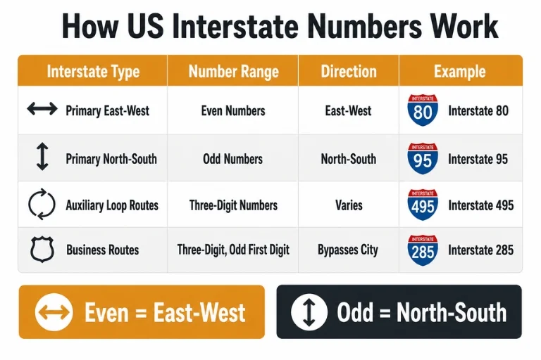
The Logic Behind Interstate Numbers
Here’s something most people don’t realize until someone points it out: united states interstates aren’t numbered randomly. There’s an actual system behind it, and once it clicks, you’ll never look at a map of interstates the same way again. Even numbers run east-west. Odd numbers run north-south. And the numbers themselves climb in a predictable direction — east-west routes get bigger as you head north (I-10 hugs the southern border, I-90 runs along the top), while north-south routes increase from west to east (I-5 on the Pacific coast, I-95 on the Atlantic).
| Interstate Type | Number Range | Direction | Example |
| Primary East-West | Even numbers | East-West | Interstate 80 |
| Primary North-South | Odd numbers | North-South | Interstate 95 |
| Auxiliary/Loop Routes | Three-digit numbers | Varies (loops, spurs) | Interstate 495 |
| Business Routes | Three-digit, odd first digit | Bypasses city centers | Interstate 285 |
Three-digit interstates are a different animal. Those are loops, spurs, and bypasses branching off the main routes, and even their first digit means something: an even first digit usually means the road loops back into its parent interstate, while an odd one means it’s a spur that ends somewhere else entirely.
A Few Interstates Worth Knowing by Name
Some routes are simply a bigger deal than others, whether because of length, traffic, or history.
- Interstate 90 – stretches from Seattle to Boston, making it the longest interstate in the country
- Interstate 95 – runs the entire East Coast, and it’s about as busy as that sounds
- Interstate 10 – cuts across the South, from California all the way to Florida
- Interstate 5 – handles most of the West Coast’s north-south traffic
The Route of Interstate 80: Coast to Coast in One Drive
If you want a taste of what makes the interstate highway system genuinely impressive, look at the route of interstate 80. It starts in San Francisco and ends in Teaneck, New Jersey — 11 states, roughly 2,900 miles, and a completely different landscape every few hundred miles. You’ll climb through the Sierra Nevada, cross the flat expanse of the Great Plains, and roll through the industrial Midwest before you’re done. It’s basically the whole country condensed into one road trip. For anyone planning to tackle a route like I-80 in an older vehicle, making sure your drivetrain is solid beforehand is essential — browse Tagore AutoParts’ used Ford F-150 engines and other truck and SUV engines perfect for long-haul road trips.
Interstates vs. Everything Else on a Highway Map
Not every road on a map of national highways is technically an interstate, and the distinction matters more than most people think. U.S. Routes — the older network, think Route 66 — were built before interstates existed and often run straight through town centers, complete with stoplights and cross streets. Interstates were designed specifically to avoid all of that.
A few practical differences worth knowing:
- Access: interstates connect only through ramps; older highways can have driveways and cross streets feeding directly onto them
- Speed: interstate limits typically run 65–80 mph, depending on the state
- Engineering: interstates require divided lanes and stricter standards for curves and grades
- Funding: interstates are mostly federally funded, while other highways lean more on state budgets
For a deeper look at the history and engineering standards behind the US interstate system, the Federal Highway Administration’s official interstate history page is one of the most authoritative references available. Long highway drives also put significant stress on automatic transmissions — if yours is showing signs of wear before a big trip, Tagore AutoParts carries dependable used transmissions for a wide range of makes and models.
Getting the Most Out of an America Highway Road Map
A few habits that tend to save people real headaches on the road:
- Keep a printed or downloaded backup alongside your GPS app, especially somewhere signal gets spotty
- Check for seasonal closures before committing to a mountain route
- Remember that exit numbers usually match mile markers, so you can estimate distance without checking your phone
- Expect rest areas roughly every 60 miles on most major interstates
- Don’t assume speed limits carry over state lines — they don’t
Planning a long interstate drive also means thinking about vehicle reliability from start to finish. Tagore AutoParts stocks used Chevy Tahoe engines and other full-size SUV engines that are popular choices among drivers who regularly cover serious interstate mileage.
Conclusion
A US interstate map is more than a wayfinding tool — it’s a pretty good snapshot of how this country actually connects, town to town and coast to coast. Once you understand the numbering logic and know a handful of the major routes, reading one becomes second nature. Next time you’re planning a trip, pull up an actual map before leaning entirely on GPS. You might notice a better route your app never would have suggested — and you’ll be a lot less likely to end up confused at an exit ramp somewhere in the middle of nowhere.
For all your vehicle parts needs — from engines and transmissions to everything in between — trust Tagore AutoParts, your reliable autoparts supplier serving customers nationwide.
Frequently Asked Questions
How many interstates are there in the US?
More than 250 once you count the auxiliary loops and spurs alongside the main routes — altogether they add up to roughly 48,000 miles of road.
What’s actually different between a US interstate map and a US highway map?
An interstate map covers just the federally funded interstate system. A highway map usually casts a wider net, including U.S. Routes, state roads, and sometimes local streets too.
What’s the longest interstate?
Interstate 90, no contest — it runs nearly 3,020 miles from Seattle to Boston.
Do interstate maps get updated often?
Yes, the interstate map is frequently updated. New construction, route adjustments and infrastructure projects mean the map you used last year might not be perfectly current, so it’s worth double-checking before a long trip.
Are all interstates connected to each other?
Most of the major ones intersect somewhere along the way. Auxiliary routes tend to be more localized and don’t always tie into the bigger network the same way.